Railway Reserve Heritage Trail - Hovea Falls to Parkerville including Park Road Falls
- Out and About
- Aug 26, 2023
- 4 min read
Updated: Jan 17
Slowly we are piecing together the various sections of the Railway Reserve Heritage Trail which runs from Bellevue to Wooroloo. So far we have explored the northern branch through John Forrest National Park between Swan View Tunnel and Hovea Falls, Parkerville to Stoneville and Stoneville to Mt Helena. We have walked the connection between north and south Mt Helena to Sawyers Valley and on the southern branch have walked Boya to Darlington and Darlington to Glen Forrest and Glen Forrest to Mahogany Creek and Mundaring
We chose to start at John Forrest National Park as we know there are toilets and picnic facilities here. Another reason is that going east is uphill so when we return west we will be travelling downhill. It is just over 5 km each way and we discovered the trail is mostly flat on this section with only an 80m gain. An added bonus was visiting Falls Road falls which are more accessible from the southern side.
At John Forrest we walked through the picnic areas which are so pretty! The trails along Jane Brook Promenade will eventually lead to access points on the Railway Reserve Heritage Trail. It is a 1km hike from the picnic areas to beautiful Hovea Falls passing the site of the old Deep Creek Bridge along the way. You are no longer able to cross over Hovea Falls from the Railway Reserve Heritage Trail so should you wish to explore the falls close up you will need to divert along the Wildflower Walk Trail and then divert off that to access the falls area.
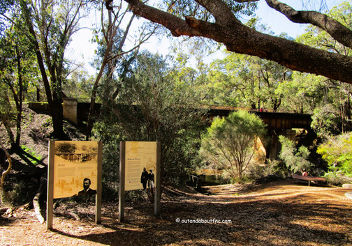
From Hovea Falls the trail takes you past two old railway bridges and then past the site of the Sustenance Camp, a flatter area alongside the brook . Then the trail continues on to the site of Hovea Station marked by a row of palm trees.
There are a few access points from Victoria Road which runs parallel to the trail, with 1-2 parking bays. We soon left the National Park and now dogs are allowed on the trail on lead. The Heritage Trail is a cycle trail as well as a walking trail so you need to be aware of cyclists at all times. Occasionally there are glimpses of Jane Brook as the trail follows the course of the stream.
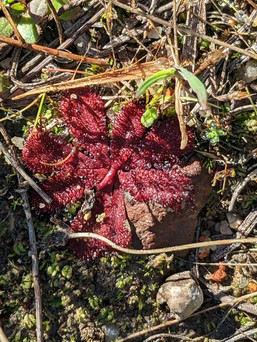
Even in July there were some spectacular wildflowers along the trail and we passed a small playground on Victoria Road. From this direction we weren't sure where the Falls Road falls were so we were looking along little access trails but they all led to private fenced properties.
Finally we got to the falls – and it is clearly signposted with a narrow trail running down to the brook displaying even more wonderful wildflowers. As water levels were high it was a bit muddy and sodden but we were able to rock hop upstream along the edges. The falls are nice but not remarkable. We walked back to re-join the Heritage Trail and a few metres further along came across another sign leading to the rocks above the rocky spill way. So it turns out to be well marked with easy access. We had previously driven along Falls Road looking for the falls but there is nowhere to park so this is a much better way to view them. In my opinion they would be better when water levels are low as the fall itself is quite small and rock hopping across the pools would be much more fun!
Either side of Falls Road Reserve there are lovely homes with the brook running through their properties. We continued on into Parkerville which is about 1km further making the Falls Road falls an easy walk from Parkerville. The trail does cross two roads before coming out at the Parkerville Hall. If you wish to access the Parkerville Tavern you can veer off along Owen Road.
This time I came prepared with the Parkerville Heritage Walk Map on my phone so we continued
along Riley St which has old turn of the century workers cottages before heading into the bush where the old quarry was located. There were some nice trails through the bush but no sign of the quarry so we headed back. As we came to the intersection opposite the Hall (1922) a convoy of vintage cars drove by adding extra interest. We walked past the Parkerville General Store (1901) which is currently closed, past more old workers cottages and turned down Owen Road to the iconic Parkerville Tavern (1901). Here we crossed the brook to re-join the heritage trail which seemed to be indicated on the Town Heritage map but we didn't see any more signs or buildings so missed a few of the sites. Some informative signage might be useful. We added 1.5km and 25 minutes to our hike exploring the Town Heritage Trail.
And so we turned back heading west towards John Forrest National Park where we enjoyed some lunch alongside Jane Brook. The hike to Parkerville took us 1 hour and 25 minutes but this included a stop at Hovea Falls, a few exploratory side trips and then the side trip to Falls Road falls
. The return downhill leg took just under an hour.
To read more blogs go to:
For blogs on other sections of the Railway Reserve Heritage Trail click on links:
https://www.outandaboutfnc.com/post/railway-reserve-heritage-trail-mundaring-to-mahogany-creek-and-glen-forrest

I love wandering along trails, both marked and unmarked, and sharing my discoveries with my Out and About FNC community. If you enjoy reading my blogs please consider a small donation which will be used towards the costs of keeping the website up to date and relevant.

In the spirit of reconciliation Out and About- Family Nature Connection acknowledges the traditional owners of the Wadjak boodjar (Perth land) and their connections to land, sea and community. We pay our respect to their elders past and present and emerging and extend that respect to all Aboriginal and Torres Strait Islander peoples today.
As always when hiking in the bush please help to reduce the spread of Phytophthora Dieback by sticking to the tracks and paths, staying out of quarantined areas and, if possible, clean your shoes before and after hiking. A spray of 70% methylated spirit and 30% water can be effective.


Comments